
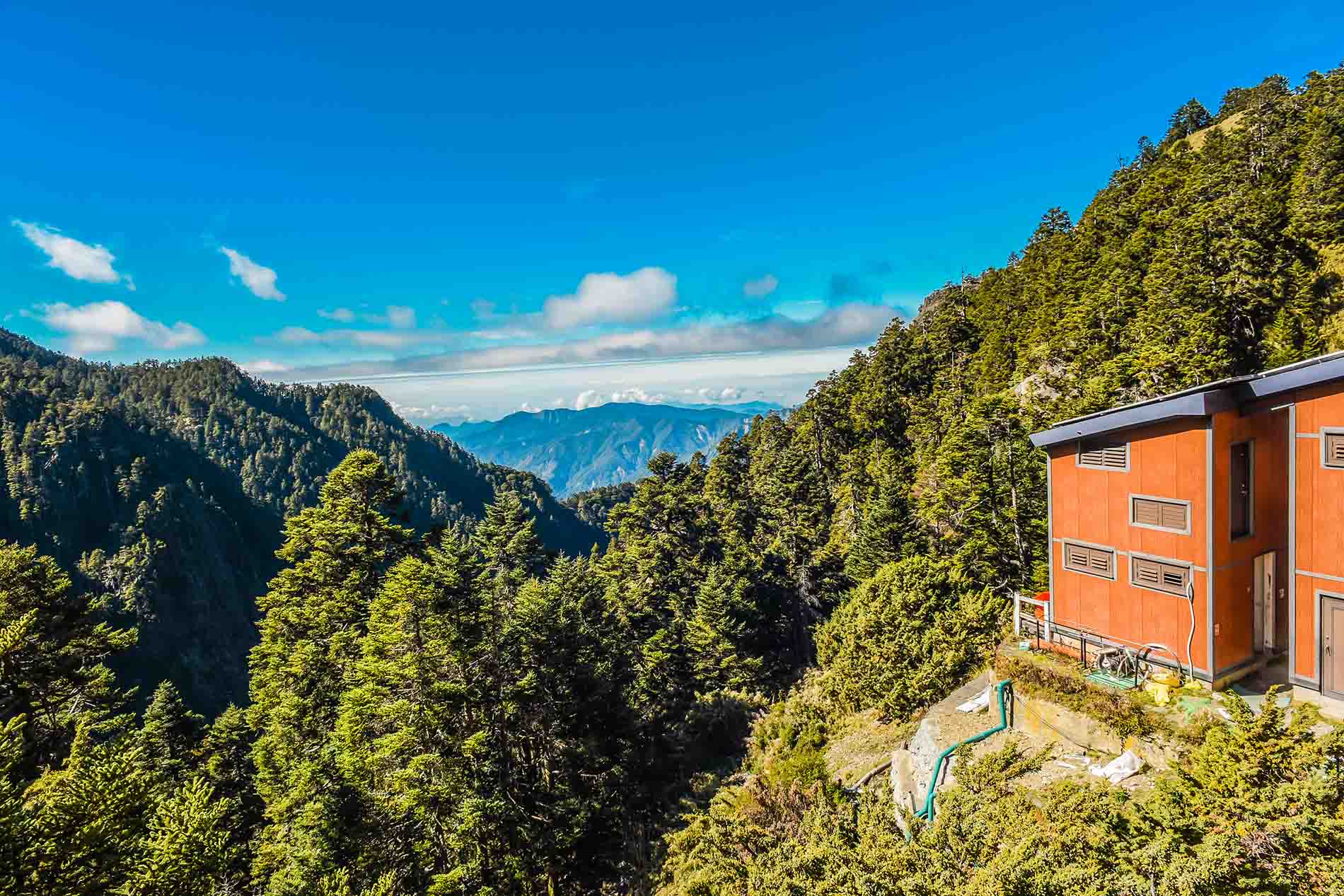
Taiwan hiking can mean completely different things depending on where you go. One day you can take the MRT from central Taipei and climb a volcanic peak overlooking the city; another day you can be above 3,000 meters, hiking through alpine forests toward one of Taiwan’s famous high mountains.
That variety is what makes hiking in Taiwan so rewarding — and also why choosing the right trail can be confusing for first-time visitors.
Some Taiwan hiking trails are easy half-day walks with no permit required, like our Yangmingshan hiking tour. Others involve high altitude, mountain huts, advance applications, difficult transportation, or several days on the trail.
This guide brings together 10 of the best hikes and Taiwan mountains for international travelers, from accessible routes such as Qixingshan and Teapot Mountain to bucket-list climbs including Yushan, Xueshan and Dabajianshan.
For each hike, we’ll explain the difficulty, typical time, elevation, permit requirements, best season, access and who the trail is best suited for.
If this is your first Taiwan hiking trip, start with the comparison below before choosing your mountain.
✨Best Taiwan Hiking Trails at a Glance
| Hike | Elevation | Typical Time | Difficulty | Permit? | Best For |
|---|---|---|---|---|---|
| Yushan | 3,952 m | Usually 2 days | Hard | Yes | Taiwan’s highest mountain |
| Xueshan | 3,886 m | 2–3 days | Hard | Yes | Alpine scenery |
| Hehuanshan | 3,237–3,421 m | 45 min–3 hrs per peak | Easy–Moderate | Usually no for common peaks | First high-altitude hike |
| Qixingshan | 1,120 m | 2.5–3 hrs | Moderate | No | Best hike near Taipei |
| Teapot Mountain | 602 m | Around 1–2 hrs | Moderate | No | Coastal mountain views |
| Dabajianshan | 3,492 m | Multi-day | Very Hard | Yes | Experienced hikers |
| Jiaming Lake | Over 3,000 m route | Usually 3 days | Hard | Yes | Alpine lake scenery |
| Beichatianshan | 1,727 m | Full day | Hard | Reserve permission | Forest lovers |
| Tefuye Ancient Trail | Mid-elevation | Half/full day | Easy–Moderate | Usually no | Forest and heritage |
| Yuanzui–Shaolai Trail | Up to about 2,300 m | Full day | Hard | No | Rock ridges and adventure |
There is no single “best hike in Taiwan.” The right choice depends on your experience, available time and how comfortable you are with altitude.
If you have never hiked above 3,000 meters, Hehuanshan is usually a much better introduction than immediately attempting Yushan or Xueshan. If you only have one day in Taipei, choose Qixingshan or Teapot Mountain. Experienced hikers looking for a serious Taiwan mountain expedition can consider Yushan, Xueshan, Dabajianshan or Jiaming Lake.

Table of Contents

Why Is Taiwan So Good for Hiking?
Taiwan packs an extraordinary range of landscapes into a relatively compact island.
Lower-elevation Taiwan hiking trails pass through subtropical forests, waterfalls, tea-growing villages and volcanic landscapes. Climb higher and the environment changes rapidly into pine and fir forests, bamboo grasslands, rocky ridges and alpine scenery.
Another advantage is variety.
You do not need to be an expedition-level mountaineer to experience Taiwan’s mountains. Some spectacular trails are reachable from Taipei in a single day, while serious hikers can spend several days crossing remote high-mountain routes.
That makes Taiwan hiking suitable for everyone from casual walkers to experienced alpine trekkers.
The important part is choosing a trail that matches your fitness and experience rather than simply selecting the highest mountain.

Taiwan Hiking Permits: What Foreign Travelers Need to Know
One of the most confusing parts of hiking in Taiwan is the permit system.
The simplest way to understand it is this: many ordinary day hikes require no permit, while national park ecological-protection routes, high mountains, nature reserves and mountain huts may require applications.
Taiwan now operates the Hike Smart Taiwan Service, which combines applications for routes administered by Yushan, Shei-Pa and Taroko national parks as well as Forestry and Nature Conservation Agency cabins, protected areas and other mountain-entry requirements.
For example, you can simply arrive and hike Qixingshan in Yangmingshan. By contrast, Yushan’s main-peak routes enter protected areas and require the appropriate applications, while Beichatianshan passes through the Chatianshan Nature Reserve and therefore requires advance reserve permission.
Do not assume that “no mountain-entry permit” means there is no application of any kind. Different agencies manage different protected areas.
For serious high-mountain hikes, check the official application system before booking accommodation or transportation.

1. Yushan (Jade Mountain, 玉山) — Best for Taiwan’s Highest Peak
Elevation: 3,952 m
Typical duration: Usually 2 days
Difficulty: Hard
Permit: Yes
Best for: Experienced hikers who want Taiwan’s most iconic summit
If there is one mountain that represents Taiwan hiking internationally, it is Yushan, also known as Jade Mountain.
At 3,952 meters, Yushan is the highest mountain in Taiwan. The standard main-peak route starts around Tatajia and climbs through forest before reaching the exposed high-alpine landscape close to the summit.
Most visitors tackle the mountain over two days, commonly spending the night around Paiyun Lodge before beginning the final summit section early the next morning.
The official Yushan trail system lists the Main Peak and West Peak route at 13.1 km one way from Tatajia, or 26.2 km return, and classifies it as a higher-level mountain route requiring park and mountain-entry permission.
Why Hike Yushan?
The attraction is not simply standing on Taiwan’s highest point.
The journey takes you through several ecological zones, and the sunrise summit experience is one of Taiwan’s classic outdoor achievements.
But this is not a hike to squeeze casually into an already packed sightseeing itinerary.
At almost 4,000 meters, altitude becomes a genuine consideration. Travelers arriving directly from Taipei or sea level should take their physical condition seriously and avoid treating the climb as a simple fitness challenge.
Choose Yushan if: reaching Taiwan’s highest mountain is a major reason for your trip.
Choose Hehuanshan instead if: you want high-mountain scenery but are not ready for a multi-day permitted climb.
2. Xueshan (Snow Mountain, 雪山) — Best for Alpine Scenery
Elevation: 3,886 m
Typical duration: 2–3 days
Difficulty: Hard
Permit: Yes
Best for: Hikers who want forests, alpine terrain and Taiwan’s second-highest mountain
Xueshan is Taiwan’s second-highest peak and one of the island’s most rewarding multi-day hikes.
The route is famous for the dramatic transition between forest and high-mountain scenery, including Taiwan fir forests and the broad glacial cirque below the summit.
Compared with Yushan, Xueshan often feels slightly more like a complete mountain journey rather than a single summit mission.
The main routes are inside Shei-Pa National Park’s ecological protection area and require advance application. Shei-Pa announced that its major mountain routes, including the Xueshan Main Peak route, had reopened after 2026 typhoon-related closures, but hikers should always check again shortly before departure because mountain access can change after storms.
Accommodation logistics are also important. The rebuilding of 369 Cabin has affected available overnight capacity, so do not base your itinerary on an old hiking blog without checking current hut arrangements.

Yushan or Xueshan?
Choose Yushan if standing on Taiwan’s highest point matters most.
Choose Xueshan if the overall mountain landscape and trekking experience matter just as much as the summit.
Both require planning well before your travel date.
3. Hehuanshan (合歡山) — Best First High-Mountain Experience
Elevation: Main Peak 3,417 m; East Peak 3,421 m; Shimen Mountain 3,237 m
Typical duration: 45 minutes to 3 hours depending on peak
Difficulty: Easy–Moderate
Permit: Usually no for the common tourist peaks
Best for: First-time high-altitude hikers, photographers and travelers short on time
If you want to experience Taiwan mountains above 3,000 meters without committing to a multi-day expedition, Hehuanshan is one of the best places to start.
A mountain road reaches extremely high elevation, allowing visitors to begin several trails already above 3,000 meters.
That accessibility is both Hehuanshan’s greatest advantage and its biggest trap.
The trails may be short, but the altitude is real.
Shimen Mountain
Shimen Mountain is one of Taiwan’s most accessible “100 Peaks.” Taroko National Park describes the summit as roughly a 30-minute climb from the trailhead, making it a popular introduction to high-mountain walking.
Hehuanshan East Peak
East Peak is much more physical. The park estimates around 1–1.5 hours to reach the summit, with approximately 300 meters of elevation gain from the trailhead area.
Hehuanshan Main Peak
Main Peak normally takes roughly 1.5–2 hours round trip. As of this October 2026 update, Taroko National Park has announced a trial reopening from October 15, while viewing platforms remain temporarily unavailable during continuing improvements. Check the status again before your visit.
Important: Altitude
It is possible to drive from low elevation to more than 3,000 meters relatively quickly.
That means someone can feel breathless, dizzy or unwell even on what looks like an easy trail.
Do not judge a Hehuanshan hike only by its distance.
If you want a privately arranged mountain itinerary with transportation, timing and hiking stops adapted to your ability, Justaiwantour can also customize a Taiwan mountain journey rather than treating Hehuanshan as a rushed photo stop.
4. Qixingshan (七星山) — Best Taiwan Hike Near Taipei
Elevation: 1,120 m
Typical duration: Around 2.5–3 hours depending on route
Difficulty: Moderate
Permit: No
Best for: Travelers staying in Taipei
Qixingshan is arguably the best answer to:
“I want to go hiking in Taiwan, but I only have one free day in Taipei.”
Located inside Yangmingshan National Park, Qixingshan combines volcanic geology, mountain views and extremely convenient access from the city.
The popular Xiaoyoukeng–Main Peak–East Peak–Lengshuikeng route is around 3.7 km and is officially estimated at approximately 2.5 hours. Another route ending at Miaopu is around 4 km and approximately 3 hours.
You will pass sulfur vents and open mountain terrain before reaching the highest summit in the Taipei Basin.
The route is far more convenient than Taiwan’s major alpine hikes because you can leave your Taipei hotel in the morning and return to the city the same day.
For travelers who would rather not manage mountain buses or route planning, see our Yangmingshan Hiking Adventure, which offers different hiking levels with private transportation and a guide.
Choose Qixingshan if: you want a real mountain hike without leaving Greater Taipei.
5. Teapot Mountain (茶壺山) — Best for Mountain + Ocean Views
Elevation: About 602 m
Typical duration: Around 1–2 hours depending on starting point
Difficulty: Moderate
Permit: No
Best for: Photographers, Jiufen visitors and adventurous day-trippers
Teapot Mountain proves that Taiwan hiking does not need to involve a 3,000-meter summit.
Located above Jinguashi near Jiufen, the trail combines rugged mountain terrain with views over the northeast coast, Yin-Yang Sea and the old mining landscape.
New Taipei City Tourism describes Teapot Mountain as one of Jinguashi’s most popular hiking trails and estimates roughly 30–50 minutes to reach the upper mountain area from Quanji Temple’s parking area.
The unusual rock formation near the summit gives the mountain its name.
Some sections around the rocks are steeper and require more confidence than an ordinary paved trail, particularly in wet weather.
Teapot Mountain works especially well for travelers who have already visited Jiufen and want something more active than another Old Street walk.
You can also combine it with Jinguashi, the Gold Museum area and nearby mining landscapes.
6. Dabajianshan (大霸尖山) — Best for Experienced Mountain Hikers
Elevation: 3,492 m
Typical duration: Multi-day
Difficulty: Very Hard
Permit: Yes
Best for: Experienced hikers seeking one of Taiwan’s most distinctive mountains
Few Taiwan mountains have a silhouette as recognizable as Dabajianshan.
Its huge block-like rock formation rises dramatically above the surrounding ridges and has long been one of Shei-Pa National Park’s defining landscapes.
This is not a casual addition to a Taiwan holiday.
The Daba route is a serious multi-day mountain itinerary requiring permits, strong fitness and much more preparation than Hehuanshan or Qixingshan.
Shei-Pa National Park identifies Daba as one of its major high-mountain routes, and its 2026 reopening announcements again highlight how access may be affected by typhoons, road damage and mountain conditions.
Climbing directly onto the summit block itself is not the point for most visitors; the extraordinary views of the mountain from the surrounding route are what make this trek memorable.
Choose Dabajianshan if: you already have multi-day mountain experience.
Do not choose it simply because: it looks dramatic in photographs.
7. Jiaming Lake (嘉明湖) — Best for a Multi-Day Alpine Lake Trek
Typical elevation: Much of the route is above 3,000 m
Typical duration: Usually around 3 days
Difficulty: Hard
Permit: Yes
Best for: Experienced hikers who want an alpine trek rather than only a summit
The lake sits deep in Taiwan’s alpine interior and requires hikers to follow a multi-day mountain route through high-elevation forest and grassland.
The official Forestry and Nature Conservation Agency classifies the Jiaming Lake National Trail as a higher-level mountain route and provides separate online applications for mountain huts and campsites.
This hike is best approached as a complete trekking experience.
The destination is beautiful, but the real appeal is the changing landscape along the way: high-mountain forests, open ridges and the sense of being far away from Taiwan’s cities.
Transportation also takes more planning than Yushan or Xueshan because the trail begins in southeastern Taiwan.
If your Taiwan itinerary is already focused on Taitung or the East Rift Valley, Jiaming Lake can make sense.
If you only have five or six days in Taiwan, it may consume too much of the trip unless hiking is your main priority.
Looking for a mountain lake closer to northern Taiwan? Songluo Lake in Yilan offers a completely different experience, with misty forest, muddy mountain terrain and a seasonal wetland at around 1,300 meters. It is still a serious hike, so check the permit requirements and trail conditions before planning your trip.
8. Beichatianshan (北插天山) — Best for Ancient Forest Atmosphere
Elevation: 1,727 m
Trail length: Official trail section 4.7 km
Typical duration: Full day
Difficulty: Hard
Permit: Nature reserve permission required
Best for: Strong day hikers and forest lovers
Beichatianshan is very different from Taiwan’s exposed alpine mountains.
Here the attraction is forest.
The mountain lies in Taoyuan’s Fuxing District and is famous for cloud forest, giant trees and autumn beech foliage.
The official trail information lists an elevation range of roughly 1,130–1,727 meters, a 597-meter elevation difference and a 4.7 km main trail section. It also notes original mountain paths, roots, streams, steep terrain and sections where mobile reception can be unreliable.
Although the site lists no ordinary mountain-entry application, the trail crosses Chatianshan Nature Reserve, so visitors need advance permission to enter the protected area. Daily capacity is controlled.
This is exactly why Taiwan hiking permits can be confusing: the rules are based on the protected area you enter, not simply the height of the mountain.
Beichatianshan is beautiful, but it is not an easy forest stroll.
Allow a full day and carry an offline route map.
9. Tefuye Ancient Trail (特富野古道) — Best Forest & Heritage Hike
Difficulty: Easy–Moderate
Permit: Generally no standard mountain permit
Best for: Families, photographers and travelers visiting the Alishan region
Not every one of the best hikes in Taiwan needs to end on a summit.
The Tefuye Ancient Trail is a strong choice for travelers who care more about forest atmosphere, history and scenery than collecting peaks.
The trail passes through dense mountain forest and follows sections associated with the old railway and the traditional lands of the Tsou people.
The Forestry and Nature Conservation Agency currently classifies the trail as Grade 2, making it substantially more approachable than Yushan, Xueshan or Beichatianshan.
It is a particularly useful addition to an Alishan itinerary because it gives active travelers something more substantial than the short boardwalk-style walks inside the recreation area.
If your priority is sunrise, giant trees and the Forest Railway rather than a full hike, read our Alishan Taiwan 2-Day Itinerary.
Tefuye is better for travelers who want to spend several hours genuinely walking through the mountain landscape.
10. Yuanzui–Shaolai Trail (鳶嘴稍來) — Best for Rock Ridges and Adventure
Elevation: Approximately 1,800–2,600 m across the wider trail system
Typical duration: Full day for longer combinations
Difficulty: Hard
Permit: No standard mountain-entry permit
Best for: Confident hikers who enjoy exposed terrain
Yuanzui Mountain gives you a completely different kind of Taiwan hiking experience.
Instead of extreme altitude, the challenge comes from steep rock, narrow ridges and sections where hikers use fixed ropes and their hands for balance.
The Forestry and Nature Conservation Agency describes the wider Yuanzui–Shaolai–Xiaoxueshan National Trail system as 15.2 km, with sections of stone steps, rock climbing, mountain trail and boardwalk. The Yuanzui section itself is famous for steep rocky terrain and exposed ridges.
This hike should not be underestimated because its summit elevation looks lower than Yushan or Xueshan.
Wet weather makes the exposed rock substantially less comfortable.
For hikers with good balance and a head for heights, though, it provides one of central Taiwan’s most exciting day-hiking experiences.
Want to Visit Taroko? Travel with a Flexible Private Itinerary
Taroko can still be included in a Taiwan trip, but road access and sightseeing areas may change due to restoration work, weather or mountain conditions.
At Justaiwantour, we check the latest official road and park updates before departure and adjust the route when needed. With a private vehicle and English-speaking driver-guide, your itinerary can remain flexible while still including available Taroko scenery and nearby East Coast attractions.
Our 5 Day Taiwan Private Tour is a good option for travelers who want to combine Taroko with other major destinations while leaving room for safe route adjustments.
What About Alishan and Xitou?
Both are excellent mountain destinations, but they serve a different traveler from Yushan or Xueshan.
Alishan is best for travelers who want mountain scenery, sunrise, forest walking, railway history and tea culture without a demanding summit.
Xitou is better for relaxed forest walking, families and travelers who want nature without serious climbing.
That is why this updated Taiwan hiking guide uses specific trails rather than listing an entire destination as though it were one hike.
For a multi-day trip that combines Taiwan’s mountain scenery with easier sightseeing, our 5 Day Taiwan Private Tour includes mountain-region travel without requiring technical hiking.

Best Time for Taiwan Hiking
There is no single perfect month because Taiwan hiking conditions change dramatically with elevation.
March to April
Spring can be excellent for lower and mid-elevation hikes. Temperatures are comfortable, vegetation is lush and flowers begin appearing in many mountain areas.
Rain becomes an increasing factor as the season progresses.
May to June
Taiwan’s plum-rain season can bring long periods of wet weather.
Forest trails become slippery, and heavy rainfall can affect mountain roads and trail conditions.
July to September
Lower-elevation hikes can be extremely hot and humid.
High mountains may offer cooler temperatures, but summer and early autumn also bring Taiwan’s greatest typhoon concern. A typhoon can close trails, damage roads or change conditions even after the storm has left.
October to November
For many visitors, this is one of the easiest periods for hiking in Taiwan.
Temperatures are more comfortable and autumn is particularly attractive for higher mountains and foliage areas.
December to February
Lower-elevation routes can be excellent in winter.
High mountains are a completely different matter. Snow, ice, strong winds and sub-zero temperatures are possible, so winter climbing requires appropriate equipment and experience.
For broader seasonal planning, see our Taiwan Weather by Month guide and Taiwan in Autumn guide.

Taiwan Hiking and Altitude Sickness
One mistake international visitors make is assuming a short trail cannot cause altitude problems.
Distance and altitude are separate issues.
This matters particularly at Hehuanshan, where a road can transport you from relatively low elevations to above 3,000 meters surprisingly quickly.
Yushan, Xueshan, Jiaming Lake and other alpine routes involve even more sustained exposure to high altitude.
Possible warning signs can include headache, nausea, dizziness, unusual fatigue and difficulty sleeping.
If symptoms become significant, continuing higher is not the solution.
Travelers with health concerns should discuss high-altitude activity with an appropriate medical professional before their trip.
For high-mountain Taiwan hiking, the safest mindset is simple: the mountain will still be there if conditions or your body tell you to turn around.
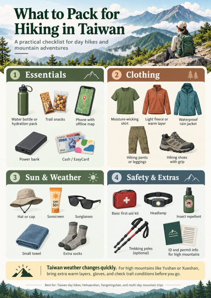
What to Pack for Hiking in Taiwan?
For an ordinary day hike around Taipei, comfortable hiking shoes, water, sun protection, a light rain jacket and a charged phone may be enough.
For remote or high-altitude routes, preparation needs to be much more serious.
Bring appropriate insulating layers, waterproof protection, sufficient water and food, a headlamp, offline route information, backup power and any equipment specifically required for the route or season.
Taiwan’s Forestry and Nature Conservation Agency also recommends GPS or positioning equipment and appropriate communication planning for more demanding mountain trails.
The biggest mistake is packing according to the weather at your Taipei hotel.
Mountain conditions can be completely different.
Guided vs Independent Taiwan Hiking
Many Taiwan hiking trails are perfectly suitable for independent travelers.
For example, experienced travelers can usually manage Qixingshan, Teapot Mountain and other well-marked day hikes after checking the route and weather.
A guide becomes more useful when your trip involves high altitude, permits, remote trailheads, mountain huts, early starts or difficult transportation.
This is especially true for visitors who do not read Chinese, because trail updates, road restrictions and emergency information are not always equally detailed in every language.
A private hiking arrangement can also solve another problem: transportation.
Some excellent trails are easy once you arrive but difficult to connect to the rest of a Taiwan itinerary without a car.
If you want the mountain experience without spending days coordinating permits, transfers and trailheads, browse our Taiwan private tours or contact us for a customized hiking itinerary.
For Taipei-based hikers, our Yangmingshan Hiking Adventure is the easiest place to start.
🥾 Which Taiwan Hike Is Right for You?
| Traveler | Best Choice |
|---|---|
| First mountain hike in Taiwan | Hehuanshan |
| Only one free day in Taipei | Qixingshan |
| Want Jiufen + hiking | Teapot Mountain |
| Want Taiwan’s highest summit | Yushan |
| Want alpine scenery | Xueshan |
| Want a multi-day lake trek | Jiaming Lake |
| Experienced mountain hiker | Dabajianshan |
| Love forests | Beichatianshan |
| Want an easier Alishan-area hike | Tefuye Ancient Trail |
| Want ropes and rocky ridges | Yuanzui–Shaolai |
For most first-time international visitors, we would not recommend selecting a hike purely from photographs.
Start with your fitness, hiking experience, number of available days and comfort with altitude, then choose the scenery.

FAQ: Taiwan Hiking
Is Taiwan good for hiking?
Yes. Taiwan has an unusually wide variety of hiking environments, ranging from short urban mountain trails around Taipei to multi-day routes above 3,000 meters. The island is especially good for travelers who want to combine hiking with city sightseeing, hot springs, food and cultural experiences in the same trip.
What is the best hike in Taiwan for beginners?
For a normal low- or mid-elevation hike, Qixingshan is an excellent introduction. For travelers specifically wanting to experience a mountain above 3,000 meters, Shimen Mountain in the Hehuanshan area is one of the easiest high-mountain options, although altitude still needs to be taken seriously.
Do I need a permit to hike in Taiwan?
Not for every trail. Many city and day hikes require no permit, but national park ecological-protection areas, high mountains, nature reserves and mountain huts may require advance applications. Use Taiwan’s official Hike Smart service to confirm the exact requirements for your route before departure.
What is the highest mountain in Taiwan?
Yushan, or Jade Mountain, is Taiwan’s highest mountain at 3,952 meters.
Can tourists climb Yushan?
Yes, international travelers can climb Yushan, but the standard routes require advance applications and mountain accommodation is limited. Plan well ahead rather than waiting until you arrive in Taiwan.
Can I hike near Taipei without a car?
Yes. Yangmingshan contains several trails accessible using Taipei-area buses, including Qixingshan. Other Greater Taipei hikes can also be reached by combinations of train, MRT and bus, although a private vehicle can make trail-to-trail itineraries much easier.
Is hiking in Taiwan safe?
Taiwan hiking can be very safe when the route matches your experience and you respect weather and closure information. However, mountains are dynamic environments. Typhoons, heavy rain, earthquakes, landslides, rockfall, snow and rapid weather changes can affect trails. Always check the current official trail status immediately before your hike.
Is Taroko open for hiking in 2026?
Only partly. Some Taroko areas are accessible, but several famous gorge trails remain closed following earthquake and weather damage. Check the latest official status and our updated Taroko guide instead of using old hiking itineraries.
What is the best season for hiking in Taiwan?
For many general hiking trips, October and November offer a good balance of temperatures and mountain scenery. However, the best season depends heavily on elevation and route. Winter can be pleasant at low elevation but demanding in the high mountains, while summer brings heat and typhoon risk.
📣 Final Thoughts: Taiwan Hiking Is More Than Yushan
Yushan may be the most famous of the Taiwan mountains, but it represents only one side of hiking here.
You can hike through sulfur-covered volcanic landscapes near Taipei, climb above the clouds at Hehuanshan, walk through misty Tsou mountain forests near Alishan, follow rocky ridges in central Taiwan or spend several days crossing some of East Asia’s most dramatic alpine terrain.
The key is not trying to climb the hardest mountain.
It is choosing the hike that fits your trip.
For a first visit, that may mean Qixingshan or Hehuanshan. For an experienced trekker, it may mean Yushan, Xueshan or Jiaming Lake. For families and slower travelers, a forest trail around Alishan may provide a better memory than any summit.
And if your ideal Taiwan hiking trip falls somewhere between those options, we can build the route around you.
Explore our Taiwan private tours or contact Justaiwantour for a customized mountain itinerary with private transportation, local guiding and a hiking pace matched to your group.